Tenby Map UK: Explore Top Beaches & Historic Hidden Gems
Who Is the Discerning Explorer? Unlocking Pembrokeshire’s Coastal Gem with the Essential Tenby Map UK

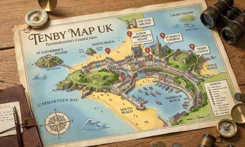
Who is the modern traveler arriving at the windswept limestone cliffs of West Wales? They are historians, beachgoers, nature enthusiasts, and curious wanderers seeking a destination that perfectly preserves the architectural echoes of the past while offering the vibrant coastal atmosphere of the present. Situated majestically on the southwestern edge of the country, the picturesque town of Tenby, known in Welsh as Dinbych-y-Pysgod or the “little fortress of the fishes,” presents a captivating labyrinth of narrow alleys, pastel-colored houses, and imposing stone fortifications. Navigating this majestic coastal resort requires more than just a casual stroll; it requires an understanding of its unique geography and historic topography. By consulting a detailed Tenby Map UK, visitors can transform a simple holiday into a deeply immersive journey through time, tracing the footsteps of Norman conquerors, wealthy Tudor merchants, and Victorian holidaymakers. The true magic of this coastal haven lies in its densely packed historical core juxtaposed against sweeping panoramas of Carmarthen Bay, making every street corner and clifftop pathway a breathtaking revelation. As you step off the modern transport links and breathe in the salty sea air, the realization sets in that this is no ordinary seaside retreat, but a living museum where the vibrant pulse of contemporary Welsh culture beats harmoniously within ancient stone boundaries.
Understanding the Historical Blueprint and Town Layout
To truly appreciate the visual feast of this seaside resort, one must first look at the town from a cartographic perspective, understanding the core structure that dictated its growth over the centuries. A high-quality Tenby Map UK reveals a distinctive triangular headland jutting out into the ocean, naturally fortified by sheer sea cliffs on the northern and eastern flanks. During the late eleventh and early twelfth centuries, Anglo-Norman invaders recognized this strategic brilliance and established a formidable stronghold to protect their interests from native Welsh uprisings. The organic, unplanned settlement that initially grew around the castle was later enhanced by a meticulously planned grid of streets during the medieval period, encompassing notable thoroughfares like St Mary’s Street and Upper and Lower Frog Street. Today, as you trace your finger along these ancient routes on your navigational guide, you will notice how the town’s architecture dramatically cascades down toward the picturesque harbor area. The structural integrity of the town was secured by the magnificent medieval town walls, which were raised and fortified following an attack in 1260, effectively enclosing the bustling mercantile settlement and separating the historic core from the later Victorian expansions. Understanding this geographical evolution is essential for anyone who wishes to comprehend why the streets bend and curve exactly as they do, reflecting centuries of adaptation to both military necessity and the unforgiving coastal environment.
The Key Landmarks to Pinpoint Within the Town Walls
The true “key” to mastering this coastal destination is identifying the pivotal landmarks that anchor the town’s historical narrative and serve as unmissable waypoints for any visitor exploring the area. The most commanding of these structures is the Five Arches, a spectacular D-shaped barbican gatehouse that dominates the western stretch of the defensive wall and serves as the primary pedestrian gateway into the heart of the old town. Once inside this protective stone embrace, the layout directs you toward the soaring spire of St Mary’s Church, the largest parish church in Wales, which acts as a central compass point visible from almost any narrow cobbled street. Just a short walk from this ecclesiastical centerpiece, tucked away on Quay Hill, lies the Tudor Merchant’s House, a remarkably preserved fifteenth-century building managed by the National Trust that offers a vivid glimpse into the domestic life of a wealthy maritime trader. Using your Tenby Map UK to locate these specific sites allows you to weave through the pedestrianized summer streets, avoiding the bustling crowds while discovering hidden courtyards, independent boutiques, and world-class seafood restaurants operating out of buildings that have stood for hundreds of years. The spatial relationship between these landmarks tells a silent story of wealth, religion, and military power, providing an unparalleled educational experience for those willing to look beyond the colorful facades.
Navigating the Four Famous Sandy Beaches
No exploration of this Pembrokeshire paradise would be complete without descending from the clifftops to experience the world-renowned stretches of golden sand that frame the peninsula in a spectacular natural embrace. The coastal topography is boldly divided into four distinct beaches, each possessing its own unique character, microclimate, and set of recreational offerings that cater to entirely different types of beachgoers. To the north lies North Beach, a spectacular sweep of sand easily identified by the iconic monolith of Goskar Rock rising dramatically from the shore, providing a sheltered environment backed by a promenade of grand Victorian townhouses. Sweeping in the opposite direction is South Beach, a sprawling, two-mile expanse of pristine sand that stretches all the way toward Giltar Point, offering ample space for kite surfers, dog walkers, and families seeking a quieter environment away from the immediate harbor bustle. Between these two giants sit the intimate coves of Castle Beach and Harbour Beach, which are heavily influenced by the shifting tides and serve as the traditional launching points for local fishing vessels and pleasure cruisers. Recognizing the locations of these beaches on your map allows you to perfectly time your visits according to the tidal charts, ensuring that you never miss an opportunity to swim in the crystal-clear waters or explore the exposed rock pools.
The Essential Map Legend: Decoding Your Navigation
Understanding the literal key or legend of your navigational tool is absolutely vital when planning your daily itineraries in a town where geographical elevation and seasonal pedestrian zones heavily dictate movement. During the peak summer months, the historic walled center is famously transformed into a pedestrian-only zone during daylight hours, a crucial detail marked on any reliable Tenby Map UK to prevent unsuspecting drivers from navigating the impossibly tight, cobbled lanes. The map’s legend will also highlight the steep gradient changes between the town center and the beaches, indicating exactly where visitors can find accessible ramps, staggered staircases, or gentle sloping paths suitable for wheelchairs and strollers. Furthermore, practical symbols will direct you to essential facilities such as the expansive park-and-ride lots situated outside the medieval walls, the various public amenities, and the bustling ticket kiosks located at the top of the harbor. These kiosks are the gateway to booking unforgettable boat trips to Caldey Island, a tranquil offshore sanctuary home to a working monastery of Cistercian monks, pristine wildlife habitats, and a famous chocolate factory. Taking the time to study these cartographic details transforms a potentially stressful logistical challenge into a seamless, highly enjoyable holiday experience where every transition from town to coast feels completely effortless.
Beyond the Walled Centre: Coastal Paths and Viewpoints
While the densely packed historic center offers endless fascination, the areas immediately surrounding the town provide some of the most spectacular natural scenery in the entire Pembrokeshire Coast National Park. Looking out from the elevated vantage point of Castle Hill, visitors can spot the tidal marvel of St Catherine’s Island, an imposing rocky outcrop crowned by a formidable nineteenth-century Palmerston Fort designed to repel a feared invasion by Napoleon III. For those with a passion for hiking, the town serves as a phenomenal access point for the Pembrokeshire Coast Path, a world-renowned national trail that offers miles of undulating cliff-top walking with uninterrupted views of the Bristol Channel. Following the path eastward toward Saundersfoot or westward toward Manorbier reveals hidden coves, dramatic limestone arches, and a diverse array of marine wildlife including grey seals and seasonal seabird colonies. Integrating these broader regional trails into your local Tenby Map UK ensures that you experience the full environmental context of this ancient settlement, appreciating how the rugged natural landscape has continuously shaped the destiny, economy, and culture of the local community over the millennia. Stepping beyond the physical confines of the town walls allows the adventurous spirit to truly connect with the wild, untamed beauty of the Welsh coastline in a deeply personal way.
Conclusion
Tenby remains an unparalleled jewel in the crown of Welsh tourism, seamlessly blending the architectural grandeur of a medieval fortress with the relaxed, sun-drenched atmosphere of a premier modern holiday resort. Whether you are wandering through the towering shadows of the medieval town walls, enjoying freshly caught seafood by the bustling harbor, or gazing out across the tranquil waters toward monastic islands, the town delivers a deeply enriching sensory experience that lingers long after departure. Armed with a comprehensive Tenby Map UK, you possess the ultimate tool to unlock the geographical secrets and historical narratives hidden within every narrow lane, ancient churchyard, and sandy cove. The true joy of visiting this vibrant coastal town lies in the exquisite balance between planned navigation and spontaneous discovery, allowing the ancient streets to guide you toward spectacular vistas and unforgettable memories. As you fold up your map at the end of the day, you will realize that you have not just visited a destination, but you have actively participated in a continuing history that stretches back over a thousand years. (For a complete list of seasonal events and activities, check out the official Tenby tourism guide.)
FAQs
How can I find the main train station using a Tenby Map UK?
Looking at a Tenby Map UK, you will easily find the railway station clearly marked just outside the main town center.
Does a Tenby Map UK indicate which local beaches allow dogs?
Yes, a good Tenby Map UK shows seasonal dog restrictions on North Beach and year-round pet-friendly zones on South Beach.
Where does a Tenby Map UK show the boats departing for Caldey Island?
A detailed Tenby Map UK will point you directly to the busy harbor area where all the island boat ticket kiosks are located.
Can a Tenby Map UK help me find parking during the busy summer months?
Definitely, checking your Tenby Map UK reveals large public car parks situated safely outside the pedestrianized medieval walls.
Which famous historical landmarks should I locate first on my Tenby Map UK? You should immediately use your Tenby Map UK to locate the iconic Five Arches gatehouse and the historic Tudor Merchant’s House.
Can I use a Tenby Map UK to find the best coastal walking paths?
Yes, a comprehensive Tenby Map UK clearly traces the famous Pembrokeshire Coast Path and highlights the most scenic walking routes around the cliffs.